
This collection of walking routes through our scenic
city takes you through some of the lesser known and residential parts of San Francisco. You'll
be surprised to see that off the beaten tourist path, there's lots to discover on tiny streets,
hidden stairways or even unpaved roads, with gorgeous views abound.
All the hikes covered in this book start with a map that gives you an
idea on which city streets to follow. On the subsequent pages, there's always a
collection of photos taken along the trail, often highlighting the most
spectacular viewpoints.
Enjoy your walking tours!
Mike Schilli m@perlmeister.com, San Francisco, September 2023

The Presidio Loop Hike is located in the central area of San Francisco's Presidio park. It is a former U.S. Army post and features various military housing units in Spanish Colonial style, which are now occupied by civilian government workers. The trail offers great views of Golden Gate Bridge, especially at the vista point next to the National Cemetery.
The trail starts at a small parking lot on Kobbe Ave. Take the steps down to the tennis courts, and find the forest track heading east towards Schofield Rd. Cross under the highway and find the Park Trail winding up to the cemetary outlook.
Then cut through to Nauman Rd, proceed on Amatury Loop, and cross under the highway again. On the forest trail heading north-west, continue to Wright Loop and back to the parking lot. See more

The Tank Hill Mount Olympus Loop Hike is jam packed with spectacular views at rarely traveled sites. Starting at Tank Hill, Twin Peaks lesser known sibling, the route leads through parts of Cole Valley and then climbs up the stairs to Mount Olympus, a residential neighborhood offering another breathtaking city view.
Downhill from there, it crosses over to Corona Heights, leading down Vulcan Stairs, crossing 17th St and then winding up Corbett Ave, before another long set of ancient stairs, the Pemberton Steps, lead back to the Tank Hill neighborhood where we started. See more

Proceed down Vulcan Stairs to the south side of Corona Heights Park, winding through and passing by pickle ball and tennis courts, to finally transfer over to the next neighborhood to surround Buena Vista Park.
Walk around park with its dense tree structures, and marvel at ancient apartment buildings with their art noveau style decor. See more

In iconic Noe Valley, you can find rather steep but rewarding routes up and down the hills facing Twin Peaks. This hike leads you up to Billy Goat Hill, offering scenic views featuring San Francisco's downtown.
But that's not all, you'll also find the even lesser known Duncan Hill with equally rewarding views of Market St, Downtown, and the Financial District. See more

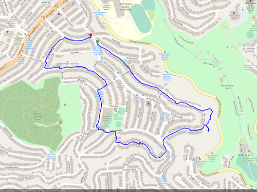
This city walk starts in the Miraloma neighborhood, west of Glen Canyon Park, and first leads to a spectacular vista point above O'Shaugnessy Blvd, overlooking the canyon and large parts of the Excelsior. After cutting through the Sunnyside Playground, it leads up a small hidden path (Lulu Alley) to the foot of Mt Davidson. Proceeding upwards on Molimo Dr, the path enters Mt Davidson Park at a hidden entry which offers amazing views of Miraloma and West Portal.
In the park with its rocky trails, the route then circles around the Mt Davidson summit, without too much change in elevation, exiting the park on the south side onto Dalewood Way. Proceeding east from here, again without much elevation change, the path leads back to our previous crossing point at Molimo Dr, from where we proceed towards Myra Way, down the Avoca Alley stairs at the playground, and follow Bella Vista Way until Teresita Blvd, which we follow until Stillings Ave leads us back to the trail entry on Malta Dr. See more
This one-way trail starts at a rarely traveled footbridge over the US-101 freeway in the Bayview, crosses into Bernal Heights, then into the Mission District, and from there leads into Noe Valley.
Enter the footbridge at the end of Faith St off of Bayshore Blvd and watch in amazement how it zig zags up to great heights and finally crosses the always busy US-101 freeway.
Upon entering Bernal Heights at the end of the footbridge, turn right and follow Holladay Ave north. At a sharp left corner, take the foot steps down to the 'hairball' freeway maze, and follow Cesar Chavez St. onto Precita Ave.
Proceed straight by the park, scale up the Bessie Stairs, follow Mirable Ave, go down the hidden stairs and onto Mission. Turn right on Mission St. and continue until 24th St, then turn left, all the way up to Noe Valley. See more
Edgehill is a secluded neighborhood adjacent to Portola Drive, not far from West Portal. The trail entrance on Ulloa St is at a gate that's open for foot traffic. Go up the hill, and at the end of the paved road, follow the forest trail which leads over to Edgehill Way. Turning right at the crossing with a rusty sculpture leads to a nice loop trail around Edgehill Heights with nice views. Coming back from the loop, proceed north on Edgehill Way, then turn left on Garcia Ave, left on Vasquez Ave and take the stairs down to Dewey Blvd.
Cross the big intersection and find the majestic stairs on the opposite side. Go all the way up, then turn right on Castenada Ave, continue upwards to Ventura Ave, then turn left at the small pathway over to Pacheo St and find the connecting stairs downwards. Wiggle down on Sotelo/Mendoza Avenues until 9th Ave, where's another set of stairs down to San Marcos and Castenada Ave. Proceed down to Taraval St., take the Kensington Way exit and make a right at the small pathway down to Dorchester Way, leading back to Ulloa. See more

Starting on Church St in Noe Valley, cut over to Slow Sanchez St, which is closed to motorized through traffic and great for walking. On 30th St, turn left, cross over busy San Jose Ave at the light and turn right into 29th St. about 500ft north. Make a left at Tiffany Ave.
Before reaching the end of Tiffany Ave, there's a small opening to the Burger King parking lot, cut through the lot, cross Mission St., and continue on Fair Ave up the hill. Proceed up the stairs, make a left at Prospect Ave, left on Coso Ave, and find the narrow stairs starting on Montezuma St and leading down to Precita Ave.
Turn right on Precita, follow it until Shotwell St, then turn left, cross Cesar Chavez and follow Shotwell St until 25th St, then turn right. Pass the soccer field at Garfield Square, turn left on Harrison, then turn left on 24th and follow it all the way up back to Noe Valley. See more
This journey begins and ends in Glen Park, and you'll be using two spectacular foot bridges over busy freeways before and after crossing into parts of the Excelsior. Start by venturing through St Mary's Park, go downhill to the playground, and keep moving towards the freeway. Cross the bustling US-280 freeway via the scenic footbridge.
Cross Silver Ave, ascend uphill, then take a right onto Pioche St. Continue your path onto Valmar Terrace, where you'll descend down the stairs to Athens St. Turn left and follow the stairs to Avalon Ave.
Stay on course on Avalon Ave as it transforms into Theresa St. Turn left to find the entrance to the another footbridge over the US-280 freeway. On the other side, find the big intersection at Diamond St, turn left and later make a right onto Wilder St. Continue along Arlington St, and when you reach Roanoke St, cross San Jose Ave over another footbridge. Follow College Ave, and cross Mission St to return to the starting point at St. Marys Park. See more

This short loop trail covers some backstreets in Noe Valley and offers a nice view down to the Bay. Start at 24th at Elizabeth St. and head west until you hit Castro St. Make a left and follow Castro, first downhill, then uphill, until you reach 27th St.
Turn left on 27th St (stairs are optional), hike over the hill, go down to the cul-de-sac, and take the stairs to descent onto Noe St. and then Sanchez St. Turn left on Sanchez and follow the slow street back to 24th or Elizabeth. See more
This loop trail starts near Balboa Park station and descends down to Cayuga Ave and Cayuga Park. About halfway through the park, take the path up to the left and exit the park onto Alemany Blvd. Turn right, and after about 200 ft, turn right again onto a path to a maze winding all the way up to a footbridge crossing the US-280 freeway.
Cross the bridge, turn left on San Jose Ave and right again at Plymouth Ave. Go uphill, and cross through the playground diagonally, following the paved path.
Exit west onto Minerva St, proceed to Orizaba Ave, then turn right and scale the steep hill. At the top, you'll find spectacular Lakeview and Asthon View Park. Exit to the east, and follow Lakeview St all the way to Josiah Ave, turn left there, and after 200 ft, turn right onto the hidden footpath leading downhill. Take the stairs all the way down to St. Miguel St., follow that to Tara Street, cross the big intersection at Geneva St and return to Balboa Park station. See more

This short loop hike begins in the area west of Twin Peaks, called Midtown Terrace. The trail starts on the dirt path next to Panorama Dr, slightly north of Mountview Ct. Proceed downwards, pass a graffiti covered water tower, and exit the trail onto the parking lot by the hospital.
Shortly after, spot the trail to your right, covered by trees, which descends down to the hospital grounds and a grassy meadow. Follow the trail into the woods, and notice a deteriorated MUNI tower which provides ventilation to the underground MUNI track leading through there.
When the trail splits into a part that leads uphill, and one that leads downhill, go right to follow the downhill path until there's a hidden exit onto Clarendon Ave. Turn right on Clarendon Ave, make a right on Olympia Way, and finally a right on Panorama Drive to get back to the starting point. See more

This route goes all around Mt Sutro, with an interesting twist. From Clarendon Ave, take Christopher Dr and go down to Warren Dr. Proceed to Locksley Ave. Make a right on Kirkham St, keep going straight up through the clinic parking area and make a right at the top, proceeding until the path is closed for traffic.
Go down on the right path, which leads to a set of metal stairs going upwards. Continue on this route (follow 'Exit' signs), passing by various pipes and machinery, until a final set of metal stairs leads down to a parking area leading to Medical Way.
Cross Medical Way and take the stairs upwards into the wooded area. Stay right, and turn left at the top. Go downwards till you hit a paved road again. Turn right into Edgewood Ave, go all the way up to the dead end. Enter the forest and follow the winding Edgewood Trail. When the trail splits, stay left, going up the Fairy Gates Trail which leads back to Johnstone Drive and Clarendon Ave. See more

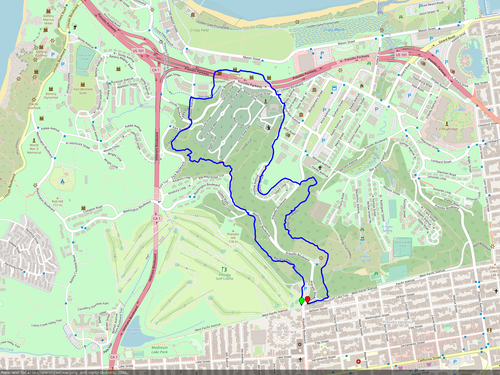
Descend into the urban Glen Park Canyon from Christopher Playground near the Diamond Heights Safeway. Turn left into the wooded area right before the last set of stairs and keep going horizontally at roughly the same elevation. Climb over the rocks that are in the way and keep following the path going slightly downward.
Keep going until you have the rec center to your right below, and climb up the stairs leading to Sussex St. At the top, turn left on Diamond Heights Blvd, then proceed upwards towards Berkeley Way. When Diamond Heights Blvd bends to the right, enter Berkeley Way and take the Onique Ln stairs up to Gold Mine Dr. Turn left and follow Gold Mine Dr all the way up, past Jade Pl, when you'll find a set of stairs to the left, decorated with mirrors, which descend down to the Safeway in the shopping center. See more

The Portrero Mission Loop starts on the east side of Potrero Del Sol Skate Park. Cross through the park, exit onto Portrero Ave, cross at the light and walk back to the first entry of Rolph Playground. Exit onto Hampshire and go towards Cesar Chavez. Use the overpath to cross and continue east on the south side, following the bike path.
At the end of the freeway maze (called 'hairball'), cross Cesar Chavez (safely at Kansas St) and walk up Vermont St, then continue on 26th St. Turn left at Wisconsin St, left on Caronline St, and cross through Starr King Open Space on dirt paths. At the bottom of Starr King, turn right and walk up De Haro St.
At the top of the hill on De Haro, turn left into 22nd St and walk down to Vermont St. Take the footbridge to cross the US-101 freeway. Continue left on Vermont on the east side of the freeway, until you hit 25th St and the starting point at the skatepark. See more

You can get to Twin Peaks by car -- or on foot from Noe Valley. Start west on Elizabeth and Church St, turn right on Douglas, left on Romain. At Market St, take the winding ramp up onto the footbridge and cross over. Continue on Romain St till Corbett St, then continue straight on by taking the stairs up to Rooftop Elementary. At the gate, turn right and follow the dirt path around the corner, then go up the stairs to Burnett Ave. Turn right. At Gardenside Dr, cross the street and take the dirt path going up by the side of the hill.
Continue on the dirt path. You can take one of two forks turning right to go up to the summit (called 'Christmas Tree Point') or continue straight and exit the dirt path on Parkridge Drive. Take the stairs down to Gardenside and Burnett. Turn left, then right down on Hopkins, right on Corbett. At the bus stop, take the path to the left, leading to another footbridge over Market St. On the other side, turn left and then right on 23rd to get back to central Noe Valley. See more

This short hike covers the north side of Glen Canyon, as a short alternative to the previous hike in the lower sections. Start from Christopher Playground, but turn right before entering the canyon and follow the path west. Stay in the higher parts of the canyon until you see a few houses on high stilts to the right, then take the fork to the right upwards towards the buildings, leading to a path with stairs going up to Amber Dr.
Turn left on Amber Dr and follow the road until Cameo Way, where you turn right. Shortly before hitting Duncan St, take the stairs down to the right and make a left when you get to Amber Dr again. At the SFPD training facility, make a right and follow the grassy path leading back to the park and the shopping center parking lot. See more

Kite Hill is easy to reach from Noe Valley, just go west on Elizabeth St, then make a right on Douglass St. Stay left when it splits and turn left on Romain St. Walk up until Grand View Ave and proceed till Grand View Terrace, where you turn right.
Enjoy the great view of downtown San Francisco when entering the often windy park, and scale down the rocky path while keeping right and exiting at Corwin St. Follow Corwin St until Douglass, and turn right to return on the same route you took previously. See more

This hike surrounds the 'Bernal' landmark hill, yet requires mastering some elevation changes. Start at Coleridge and Eugenia St, going up Eugenia, and follow the street all the way to Prentiss St, where you make a left uphill, followed by a right on Powhattan Ave.
When it becomes Franconia St after a sharp left turn (note US-101 down far below), follow it till the dead end where there's a set of stairs leading upwards, called 'Peralta Stairs'. Up there, keep going straight following Peralta, until at Samoset St there's a tiny park on the left. Enter it and try out the swing! Take the steps down to Rutledge St, turn left, then left on Alabama St, and make a right on Ripley St.
Follow Ripley all the way to Folsom St, cross Folsom, and enter the dirt path after climbing over the guard rail. Keep going upwards on the dirt path until it meets Bernal Heights Blvd, follow that to the stairs leading down to Esmeralda Ave. Slide down the Esmeralda slide and you're back at Coleridge. See more

Park at 18th and Utah St and get on the footbridge crossing I-80. Turn right and walk upward on San Bruno Ave. Upon entering McKinley Square, either stick to the route closest to the freeway or twisting Vermont St, also known as 'Lombard of Locals'. At the bottom, turn left and walk up the steep hill on 22nd St. Behind the 'Dead End' sign at the top, find the stairs down to Arkansas St and then keep going straight following the dirt path.
Stay right to surround the rec center and exit again on Arkansas St further south. Follow 23rd St west and enter Starr King Open Space and check out the swings. Cross diagonally through the grass and exit west onto De Haro St., to walk south. Make a right on 26th St. and follow Vermont down to Cesar Chavez.
Follow the bike lane through the freeway maze, then cross through Rolph Playground to get to Hampshire St. Continue going north, until 18th St, then turn right to get to the parking location. See more

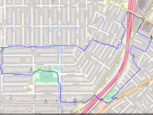
Park neart 18th and Tennessee St and cross over 3rd street to enter the greenspace at the shoreline. Exit the greenspace on its north end but continue to follow the shoreline along Terry A. Francois Blvd, passing by Chase Center and finally arriving at the 3rd St bridge over Mission Creek. Follow Mission Creek west, first on the north, then on the south side.
Cross 7th St and follow Channel St, then Carolina St down to 16th St, cross over and continue to Jackson Park. Cross over the Potrero Hills to 20th St and proceed west, cross I-280 on the overpath, continue to Tennessee St, then turn left to get back to the starting point. See more

Park at 15th Ave and Wedemeyer St at the Presidio Landmark and take the Lobos Creek Valley Trail down to the beach. You can walk on the beach almost all the way to the north end, but the last exit is the 'Sand Ladder' a few hundred yards before that.
The trail leads you back to Washington Blvd in the Presidio. Make a right on Battery Caulfield Rd to get back to the parking location. See more
Park on Marietta Dr at Evelyn Way. Go down Marietta until a dirt path opens up on the left side when Marietta makes a sharp right turn. Explore the path, you'll be standing on top of a cliff, and there's great views of Glen Canyon and the Excelsior to be enjoyed.
Return to Marietta, cross Teresia Blvd, and continue on Molimo Dr. Make a right at Dorcas Way and turn left on Bella Vista Way. Take the stairs up to the right and turn right on Myra Way. Follow Myra till La Bica Way, turn right and then left on Rockdale Dr. Turn right at Chaves Ave and right on Evelyn to get back to the parking location. See more

Starting from 24th St at 'slow' Sanchez St, go south on Sanchez until 30th, then turn right and walk up the steep hill until Laidley, then cross over to the left. Follow Laidley till Roanoke, turn left and go down the hill, find the footbridge over San Jose Ave and cross over. Find the small paved footpath going north, starting at St. Marys Ave going parallel to San Jose Ave, it's called 'Bernal Cut'. Follow the path until Highland Ave, then turn right.
Follow Highland Ave until Patton St, turn left, and find Gladys St to the left when you arrive at Appleton Ave. Follow Gladys until Santa Marina St, turn right and take a left up the stairs to Prospect Ave after 100 yards. Follow Prospect Ave until Virginia Ave, turn left and follow Virginia, cross Mission St and continue on Tiffany Ave.
When Tiffany ends at Duncan, turn left and follow Duncan, first crossing San Jose Ave, then Dolores St. On Church, make a right and continue to the starting point at 24th St. See more

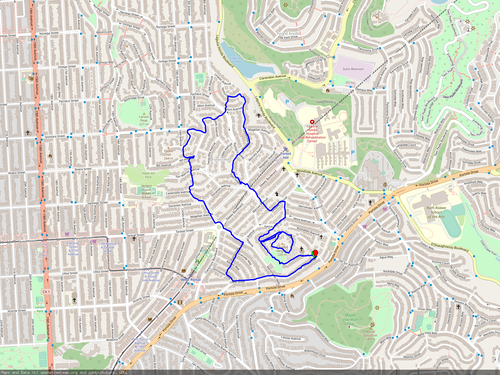
This hike goes all around Mt Davidson. It starts at Myra Way and Molimo Dr. Walk uphill on Molino Dr until you see a somewhat hidden dirt path park entrance and proceed up the rocky path. Enjoy the views of Miraloma in the open space, continue into the forest and then take the first fork to the right after about quarter mile. Descend on the path, keep right when it forks. Exiting the park at La Bica Way, make a left on Rockdale Dr, right on Chaves Ave, left on Del Sur Ave, and left on Juanita Way.
Follow Juanita Way until it ends at Landsdale Ave, then turn right. Follow the road uphill, and make a left Robinhood Dr. Follow Robinhood Dr all the way uphill until it levels out and make a left on Landsdale Ave, and continue on Myra Way to the starting point. See more

Park at 43rd Ave and Geary Blvd, walk up 43rd to Clement St, cross over and find the foot path veering off slightly to the right, leading straight into the VA Medical Center. Keep going north, cross Veterans Dr and continue on the foot path. Walk along the buildings and keep left when the space opens up, to find the 'Battle-of-the-Bulge' path leading downhill into a dune like landscape.
Stay left when the path meets El Camino del Mar and then follow the steps and path heading to Lands End. Keep following the path when it makes a left turn to head south, remain on the outer edges for great views.
Continue to Point Lobos Ave, cross over and continue on the dirt path leading into Sutro Height Park with great views of Ocean Beach. Head down the stairs to Balboa St, turn left and keep going till 43rd Ave, turn left and head up back to the parking location. See more

This hike circles around Twin Peaks and offers spectacular views in all directions. Park at Panorama Dr shortly after exiting from Portola Dr. Walk over the hill on Panorama, make a right at Cityview Way, then a left at Knollview Way, leading you back to Panorama Dr.
Turn right at Marview Way, and go up the somewhat hidden stairs on the left after about 100 yds. On Fairview Ct., turn right, cross Marview Way and find the dirt path starting just right of the gate and fence. It leads by Twin Peaks Reservoir uphill to Twin Peaks Blvd. Turn right on Twin Peaks Blvd, taking the narrow dirt path beside the street and guide rail. Venture over to Christmas Tree Viewpoint if you want. Continue the trail by passing trough the cement barriers which close the east part of Twin Peaks Blvd to traffic.
Follow Twin Peaks Blvd until the closed section ends and take the dirt path and steps down to the left. On the second crossing, cross Twin Peaks Blvd and walk it down all the way to Portola Dr. See more

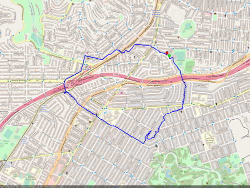
Park on Oakdale Ave at Bayshore Blvd, cross at the light and find tiny Faith St, leading up to a footbridge ramp over US-101. Turn right on Holladay Ave, follow it till a sharp left bend, then descend on the stairs leading down to the freeway hairball. Follow the bike path east, cross Cesar Chavez (safely at Kansas St) and walk up Vermont St. Continue on 26th St, turn left on Wisconsin St, right on 25th, and right on Pennsylvania. Cross Cesar Chavez and find the bike/footpath opening on the other side, wedged between Freeway exits.
Walk down the enclosed bike/footpath, follow it along Islais Creek Channel and enter Tulare Park. Proceed through the Skatepark, go down the stairs and keep going despite the walkway ending. There is a gap in the metal fence, slip through it to enter 3rd St.
Go south on 3rd St till the end of the bridge, past Custer Ave, and then turn right on Phelps St.. Follow it for a mile and then turn right on Palou Ave, which leads back to Oakdale (stay right). See more

On Sacramento St. near Baker, walk north through the library garden, then turn left on Clay St and right on Lyon St. Follow Lyon St, proceed down the stairs and then turn right on Green St. Make a right on Baker St, scale the Baker street steps and go left on Broadway, San Franciso's 'Billionaire Row'. Proceed until Scott St, turn right. At Jackson St, explore the park and then go east on Washington St to the starting point. See more

Start this hike on Masonic Ave between Turk Blvd and Anza St, enter the Lone Mountain campus on the east side, traverse through to Anza St and then go back uphill over the stairs until you're at the chapel level. Exit the campus on the south west corner, taking the paved pathway that starts to go west between Turk Blvd and Anza St.
Arriving at the Angelo Rossi playground, turn right and walk around to the closest entrance on Anza St. Pass through the playground, exiting on Arguello Blvd at the short stairs.
Go south on Arguello, enter Golden Gate Park and turn left onto the dirt path after 100 yds. Stay on the path until you see the Rec and Park log cabin, walk around it, and exit onto the Pan Handle. Walk east on the Panhandle bike path till Central Ave, then turn north and get back to Turk Blvd, and to the starting point. See more
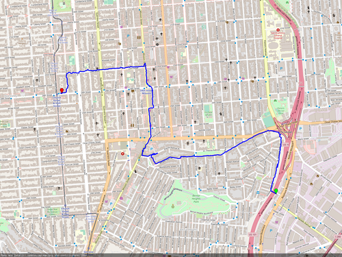
Start at the Presidio Arguello entrance. After the golf course lot, turn left on the Bay Area Ridge Trail. Walk until it exits onto Washington Blvd, follow it, then make a right to follow Nauman Road.
Turn right onto the dirt path, leading to the cemetery viewpoint. From there, take the stairs down to Park Blvd. Continue south on McDowell Ave and after about 300 yds, there's a paved footpath going off to the right, leading you to Presidio Battery Bluff Park.
Passing all the way through the park, you'll end up on Sheridan Ave, which forks off Infantry Terrace after 300 yds. Follow that uphill, go around the big left turn, to end up on Arguello Bvld again. Find the dirt path leading into the woods a bit left of where you exited, follow that, and turn right onto Ecology Trail shortly after. This leads you back to either Inspiration Point or west Pacific Ave to bring you back.

From 24th and Church St, proceed to slow Sanchez and walk south until 27th St. in Noe Valley. Turn right on 27th St and climb up the hill until Castro St, then turn left, climb Duncan Hill and continue south to 28th over the stairs.
Turn right on 28th St, then left on Diamond St, pass the 29th and Diamond open space, and then take Beacon St down to the left. With Billy Goat Hill to the left, take the steps to the right up to Walter Haas Playground. Exit the playground on the south end, onto Farnum St, continue walking to Moffitt St, turn left, then right on Diamond St, and then right on Arbor St.
Turn left on Conrad St, and after about about 100 yds, there's Poppy Ln to the left. Follow that until it exits onto Diamond St, then turn left into Penny Ln after 100 yds. At the end, turn left, up the stairs to Sussex St, right onto Castro and left onto Laidley. Follow Laidley all the way to 30th St and turn right to get back to central Noe Valley. See more